Tomales Bay is one of the best places in California to kayak through bioluminescent plankton, but you can only see it if three things align: it has to be dark enough (moon below the horizon), late enough (after full darkness), and the right season (late spring through fall when dinoflagellate populations peak). These are my planning notes for boat-in camping on the Bay. For how it actually went, see my trip reports:
See also the NPS Plan Your Visit site.
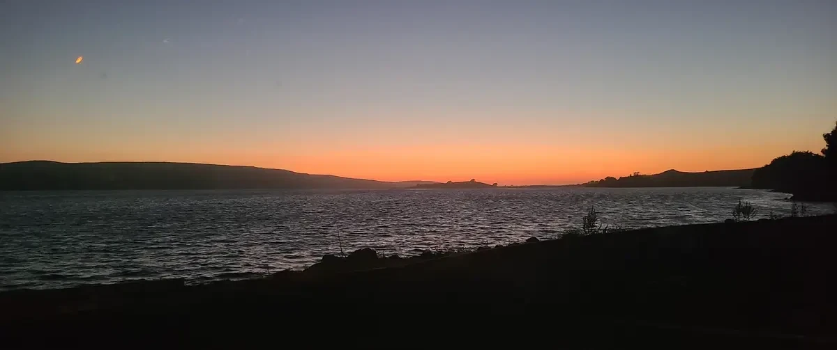
Kayak Rentals
Blue Waters Kayaking at Point Reyes Station rents double kayaks overnight for $198 (500 lb weight limit), which works out to about $100 per person.
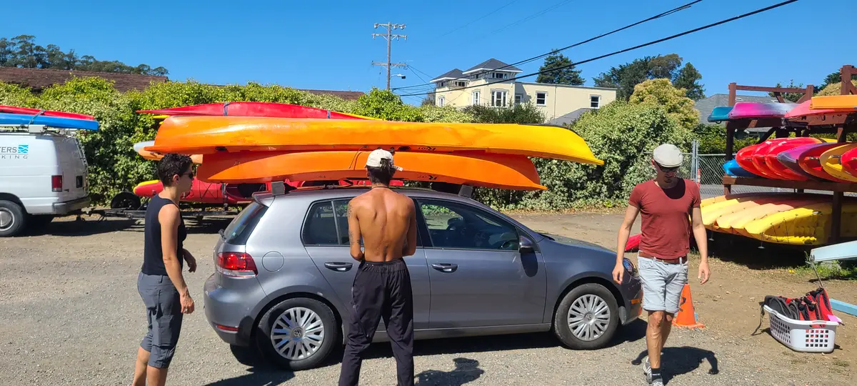
Gear checklist
Group gear
- Permits
- Boat-in permit - must be displayed on the dashboard of every vehicle at Miller Boat Launch for overnight parking. The NPS website says you need to print this, but I've never been able to find it. I've successfully written my reservation number large on a piece of paper and left it on the car dash several times without issue.
- Campfire permit from this site. You have to print and bring the permit with you and call the information line the day of your fire to see if fires are permitted on that day.
- Navigation
- Offline maps and GPS points for campsites.
- Kayaking
- Kayaks
- Paddles
- PFDs
- Bilge pump (if closed deck)
- Paddle float (if closed deck)
- Faint red light for stern. This isn't a legal/actual navigation light, but is useful for keeping track of where each other's kayaks are in the dark. Putting one on the front would detract from being able to see the bio. I haven't tried this idea, yet.
- Headland beacon light - A coloured light to leave behind on the beach so you can find camp after a night paddle. I prefer leaving it on a headland so it's visible from a distance rather than provoke the anxiety of maybe having missed it were it left deeper in a Bay. I found the AlpenGlow Mini Lantern to work well - it's multicolor feature makes it easy to spot at night.
- Tent target light - Putting some fairy lights on or near the tents allows you to navigate to them easily after you pass the beacon light
- 55 gallon trash bags - useful for putting one's legs in on an open deck kayak to avoid getting them wet. Also needed since everything going on an open deck kayak needs to be waterproofed against spray somehow.
- Dry bags - useful for things that absolutely need to stay dry (warm clothes, matches) or items that might fall into the water
- Dry bag for cellphone/camera - I still haven't figured out a good way of handling this and usually put the camera between my legs beneath a spray skirt. A waterproof phone is probably best.
- Paracord/bungees/rachet straps - to attach things to the kayaks. Rachet straps are necessary mostly for the closed deck kayak in case not everything fits inside.
- Knife - for cutting paracord
- Kayak transport
- Rachet straps - for attaching kayaks to car. Bring at least 6.
- Camping
- Toilet paper - for the usual purposes, but also to dry/clean pots and silverware
- Wag bag / portable toilet - Marshall and Tomales Beach have latrines, but any other beach requires packing human waste out. Also useful in case someone has an emergency while you're paddling elsewhere.
- Lots of water.
- Tent with rain fly - In the fall it gets cold and dewy by the water
- Firewood - both Palace Market and Ace Hardware sell this in Point Reyes Station. Scavenging goes against minimal-impact principles and you'll also end up with a smaller, smokier fire.
- S'mores supplies
- S'mores roasting sticks
- Stove
- Fuel
- Lighter/matches
- Pot for boiling water
- Freeze-dried food or other food
- Bear can
- First aid kit
- Tarps for sitting on the beach (eg, this or this)
Personal gear
- Technical gear
- Neoprene gloves (essential) - or some kind of gloves. Every time I've run this trip we've paddled ~6 miles. Without gloves hands will get cold and blistered.
- Whistle (recommended) - something that can be attached to your PFD. We haven't had to use these, but I imagine them being useful at night or in coastal fog if the kayaks become separated.
- Compass (optional) - for wayfinding in coastal fog. I think fog's unlikely at Tomales Bay, but it's cheap insurace.
- Water + feet (recommended) - At least one person and likely two per trip will need to get their feet wet pulling kayaks into and out of the water.
- Water shoes (optional) - There's some metal and maybe fish hooks at Miller Boat Launch, so a protective sole is a good idea. XtraTuffs might also work.
- Neoprene socks (optional) - with wool socks underneath. I've used these instead of the above.
- Tarp, big garbage bag, or waterproof cloth - for keeping legs dry on open deck kayaks
- Hiking and staying warm
- Non-cotton clothes - it's easy to get wet kayaking and the coast gets cold, especially in the fall, so wool is a good choice
- Headlamp with red light mode, ideally waterproof
- Spare headlamp batteries
- Wool socks
- Extra layers - puffy is useful in the fall
- Rain pants (recommended) - can be used instead of garbage bag
- Rain jacket (recommended) - helps cut wind and keep you dry in kayak
- Hat/bandana - sun is relentless when crossing Tomales during the day
- Buff (recommended) - useful as a scarf or sun protection
- Sunglasses and a sunglass strap
- Warm hat
- Warm gloves
- Spare underwear - it's easy to sit in a puddle
- Camping and personal
- Sleeping bag - October nights can drop to 40-50F
- Sleeping pad
- Plate/bowl
- Eating utensils
- Camp towel
- Sunscreen
- Chapstick
- Phone
- Personal hygiene items
- Hand sanitizer
- Knife
- ID
- Medical insurance information
Launch points
Three launch points have overnight parking for boat-in campers:
| Launch | Phone | Lat | Lon | Notes |
|---|---|---|---|---|
| Miller Boat Launch | 415-499-6387 | 38.2000 | -122.9215 | East shore, Hwy 1 north of Nick's Cove. Cement ramp, pier, restrooms. Overnight parking in upper lot; display Recreation.gov confirmation on dashboard. No camping or beach fires. |
| Tomales Bay Resort | 415-669-1389 | 38.1071 | -122.8629 | West shore, 0.9 mi north of Inverness. Only west-shore overnight parking option. Fee required. |
| Lawson's Landing | 707-878-2443 | 38.2322 | -122.9683 | Dillon Beach, north end of bay. Sand-bottomed ramp; forklift or 4WD launch. Dump station, boat rentals, restrooms. Day-use fee; overnight parking requires purchasing a campsite. |
Tomales Bay Resort is by Chicken Ranch Beach (38.109940, -122.865088) and I believe in 2022 we were able to leave our cars parked by the roadside there for free. Lawson's Landing does not look like a good place to launch from - it's outside the mouth of the Bay where you'll be encountering the ocean directly.
Where to camp
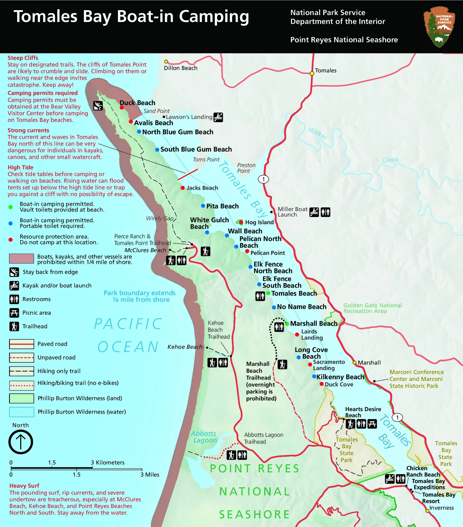
(click image for PDF)
Permit-required boat-in campsites, south to north:
| Beach | Lat | Lon | Notes |
|---|---|---|---|
| Kilkenny Beach | 38.1456 | -122.9037 | |
| Long Cove Beach | 38.1521 | -122.9108 | |
| Marshall Beach | 38.1631 | -122.9155 | West shore, due west of Hog Island Oyster Co. Vault toilets. |
| No Name Beach | 38.1692 | -122.9214 | |
| Tomales Beach | 38.1739 | -122.9236 | Long sandy beach. Vault toilets. |
| Elk Fence South Beach | 38.1763 | -122.9269 | |
| Elk Fence North Beach | 38.1808 | -122.9305 | |
| Pelican North Beach | 38.1889 | -122.9367 | |
| Wall Beach | 38.1924 | -122.9413 | |
| White Gulch Beach | 38.1935 | -122.9465 | |
| Pita Beach | 38.2030 | -122.9503 | |
| Jacks Beach | 38.2098 | -122.9599 | Closed to camping since March 2018. |
| Blue Gum Beach | 38.2264 | -122.9770 | Strong tides and currents. |
| Avalis Beach | 38.2303 | -122.9807 | Closed to boats and camping since May 2023. |
| Duck Beach | 38.2351 | -122.9850 | Closed to boats and camping since May 2023. |
If you do not have a portable toilet, you are required to camp at Marshall or Tomales Beach, where there are vault toilets that you will need to use.
Distances and paddle times
Estimated distances and times from each launch point. Miller direct is the straight open-water line; Miller via shore crosses to the west shore at a waypoint near Pelican North Beach (38.190°N, 122.935°W), then follows the shore. Times calibrated at 2.65 mph (user's group: Chicken Ranch Beach → Marshall Beach in 2 hours over 5.29 miles). Actual time depends on fitness, current, and wind.
| Campsite | Miller direct | Miller via shore | Chicken Ranch Beach |
|---|---|---|---|
| Kilkenny Beach | 3.9 mi / 1:28 | 5.0 mi / 1:53 | 3.8 mi / 1:26 |
| Long Cove Beach | 3.4 mi / 1:16 | 4.3 mi / 1:39 | 4.4 mi / 1:40 |
| Marshall Beach | 2.6 mi / 0:58 | 3.5 mi / 1:19 | 5.3 mi / 2:00 |
| No Name Beach | 2.1 mi / 0:48 | 2.9 mi / 1:06 | 5.9 mi / 2:13 |
| Tomales Beach | 1.8 mi / 0:41 | 2.5 mi / 0:57 | 6.2 mi / 2:22 |
| Elk Fence South Beach | 1.7 mi / 0:38 | 2.3 mi / 0:51 | 6.5 mi / 2:28 |
| Elk Fence North Beach | 1.4 mi / 0:32 | 1.9 mi / 0:42 | 6.9 mi / 2:37 |
| Pelican North Beach | 1.1 mi / 0:26 | 1.1 mi / 0:26 | 7.6 mi / 2:53 |
| Wall Beach | 1.2 mi / 0:27 | 1.4 mi / 0:32 | 8.2 mi / 3:06 |
| White Gulch Beach | 1.4 mi / 0:32 | 1.7 mi / 0:40 | 8.5 mi / 3:13 |
| Pita Beach | 1.6 mi / 0:36 | 2.5 mi / 0:57 | 9.3 mi / 3:30 |
| Jacks Beach ⚠ | 2.2 mi / 0:50 | 3.3 mi / 1:14 | 10.0 mi / 3:48 |
| Blue Gum Beach | 3.5 mi / 1:20 | 4.9 mi / 1:50 | 11.6 mi / 4:24 |
| Avalis Beach ⚠ | 3.8 mi / 1:27 | 5.2 mi / 1:59 | 12.0 mi / 4:32 |
| Duck Beach ⚠ | 4.2 mi / 1:36 | 5.7 mi / 2:09 | 12.5 mi / 4:42 |
⚠ closed to camping. Generation script: github.com/r-barnes/tomales-biolum.
Wind
Afternoon winds can make the crossing difficult — kayak outfitters on the bay typically cut off rentals at noon. The table below shows average wind speed (mph) by month and time of day, measured at NOAA's Point Reyes coastal station, about 10 miles south of the bay on the outer Point Reyes Peninsula, 2010–2019. Winds in the bay itself may be somewhat lower due to surrounding terrain. From the two trips I've taken, I'd say the 9PM and midnight times below are definitely an over-estimate. - Tomales Bay was almost still on both occasions.
| Month | 9 AM | Noon | 3 PM | 6 PM | 9 PM | Midnight |
|---|---|---|---|---|---|---|
| Jan | 7.5 | 8.5 | 10.1 | 9.7 | 8.4 | 8.1 |
| Feb | 9.4 | 11.2 | 13.1 | 12.6 | 11.6 | 11.1 |
| Mar | 9.6 | 10.5 | 12.0 | 12.4 | 11.6 | 11.4 |
| Apr | 11.5 | 12.9 | 15.3 | 15.9 | 14.6 | 13.6 |
| May | 13.3 | 13.8 | 16.3 | 17.1 | 16.2 | 15.5 |
| Jun | 13.7 | 14.9 | 16.2 | 17.5 | 16.7 | 15.5 |
| Jul | 9.2 | 9.8 | 11.1 | 12.0 | 10.9 | 10.5 |
| Aug | 8.1 | 8.6 | 10.9 | 12.4 | 11.2 | 10.3 |
| Sep | 8.4 | 9.5 | 12.5 | 13.2 | 12.3 | 10.7 |
| Oct | 7.3 | 9.0 | 12.1 | 12.2 | 11.0 | 10.0 |
| Nov | 7.7 | 9.7 | 11.5 | 10.8 | 9.6 | 8.8 |
| Dec | 8.4 | 9.4 | 10.7 | 10.3 | 9.1 | 8.7 |
The bioluminescence planner below shows these averages for each month as a reminder.
For current conditions and forecasts:
- NWS Point Reyes forecast
- Windfinder Tomales Bay
- Windy.com
- NWS marine forecast (PZZ545)
- NWS Coastal North Bay marine zone
Data source and station search notes
The table uses NOAA NDBC station PRYC1 (37.996°N 122.977°W), a land-based C-MAN station on the outer Point Reyes Peninsula, averaging 2010–2019 top-of-hour UTC observations converted to Pacific time. The station's wind anemometer stopped reporting in 2020.
No comparable replacement was found: NDBC buoy 46013 (Bodega Bay offshore) reads ~30% higher due to open-ocean exposure; the WRCC Pt. Reyes RCA field station (38.094°N 122.950°W) covers 2006–present but historical data requires a paid access code (wrcc@dri.edu). Personal weather stations at Inverness (KCAINVER2, KCAINVER14) and Olema (KCAOLEMA3) are all offline with no archived data. NCEI's ISD history file contains no stations for Inverness, Olema, or Point Reyes Station town. Analysis code and raw data: github.com/r-barnes/tomales-biolum.
When is there bioluminescence?
Nights with calm waters and little wind are probably best.
Local guides say the following:
- August through November, coinciding with neap tides (link)
- June through mid-October (link)
- "Bioluminescence tends to be strongest in the summer and fall, although in recent years it has been seen regularly throughout the spring as well." (link)
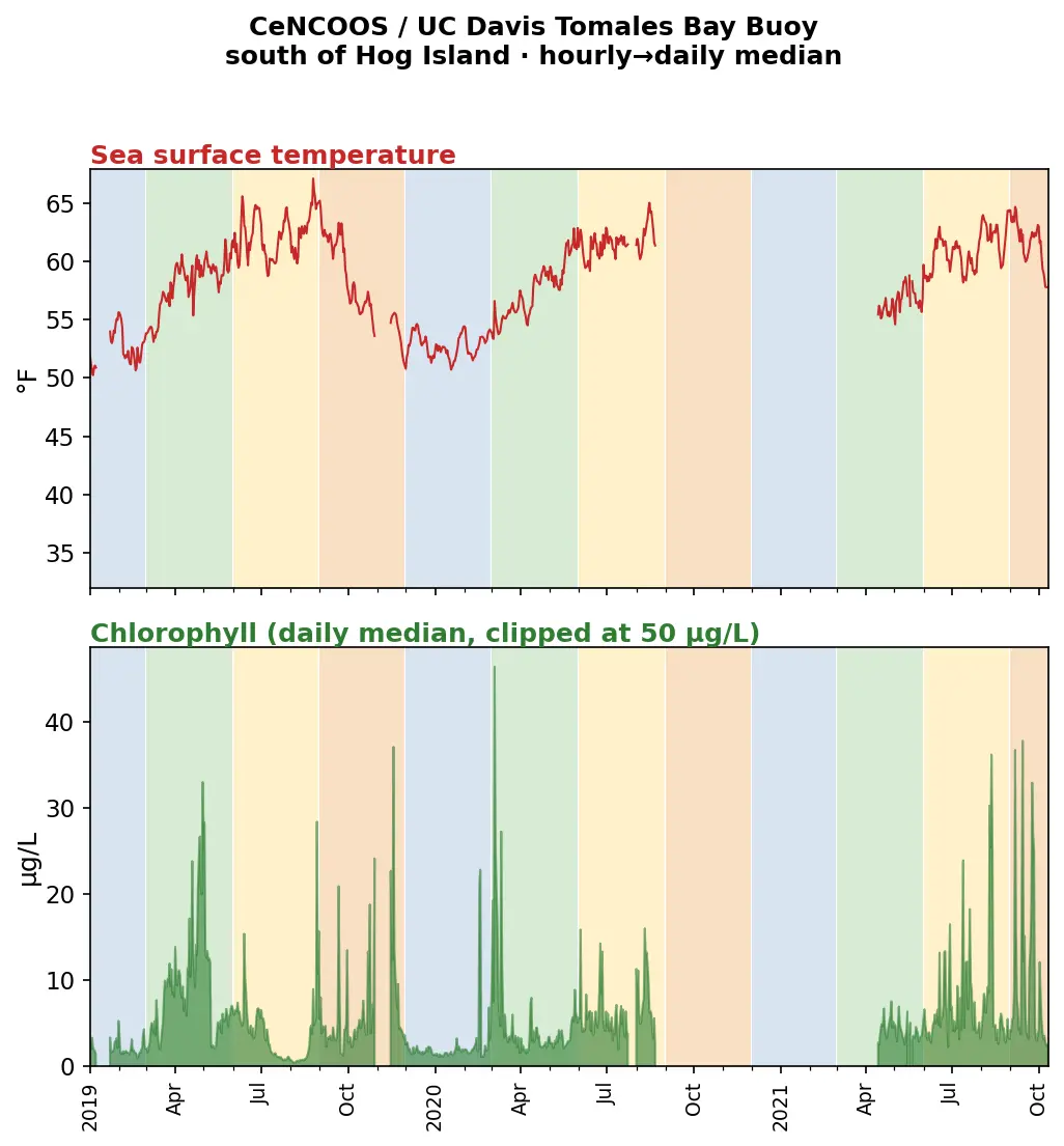
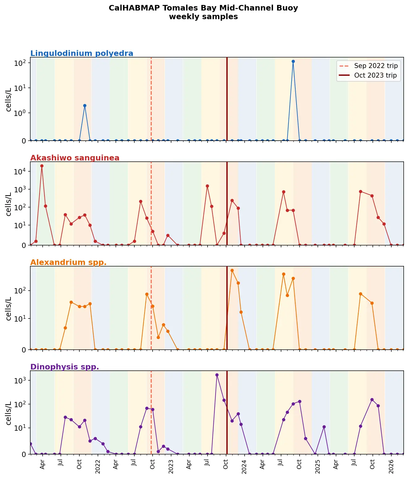
But why settle for anecdata from guiding companies in the area (/s!) when we can do Science to this? The plots below draw on three monitoring datasets and have seasonal shading: green = spring (Mar–May), yellow = summer (Jun–Aug), orange = fall (Sep–Nov), blue = winter (Dec–Feb).
Species in the data
The monitoring programs track harmful algal bloom (HAB) species. Here's who's who and what they mean for bioluminescence:
- Lingulodinium polyedra ✨ — the bioluminescent dinoflagellate responsible for California's famous glowing red tides. When mechanically disturbed at night (by a paddle, a wave, a fish), it emits brilliant blue flashes. High cell counts strongly predict visible bioluminescence; the data show it rarely blooms in Tomales Bay or at nearby Bodega Bay. Given the excellent bioluminescence I saw in October 2023, it either has a separate population in the Bay that doesn't track with collected data or Tomales Bay glows with something else.
- Noctiluca scintillans ✨ — another bioluminescent organism (technically a non-photosynthetic dinoflagellate) that can produce green daytime blooms and blue nighttime glow. Not tracked by CalHABMAP; iNaturalist observations within 100 km of Tomales Bay are sparse and mostly from San Francisco. California has a mutant population that doesn't glow.
- Akashiwo sanguinea — a non-bioluminescent raphidophyte that dominates fall blooms in Tomales Bay. Forms brown/rust-colored surface scums; can cause fish kills through gill damage and oxygen depletion, but produces no toxins and no glow.
- Alexandrium spp. — dinoflagellates that produce saxitoxins causing paralytic shellfish poisoning (PSP). Not bioluminescent. Their presence drives routine shellfish harvesting closures in Tomales Bay.
- Dinophysis spp. — dinoflagellates that produce okadaic acid, causing diarrhetic shellfish poisoning (DSP). Not bioluminescent.
- Pseudo-nitzschia (two size groups) — diatoms that produce domoic acid, causing amnesic shellfish poisoning (ASP). Not bioluminescent; responsible for periodic closure of Dungeness crab fisheries along the California coast.
Though not all the species above have bioluminescence and the bioluminescent ones are absent from the data, some bioluminescent species are predatory. Noctiluca scintillans, for instance, is heterotrophic (no photosynthesis) and feeds on phytoplankton: diatoms, dinoflagellates, fish eggs. The large Akashiwo sanguinea fall blooms visible in the data could plausibly support Noctiluca populations, meaning those non-glowing blooms might indirectly predict bioluminescence from Noctiluca even when Lingulodinium is absent. Lingulodinium is primarily autotrophic (photosynthetic) so it can't feed on these other blooms, but might benefit from the same conditions which cause them.
Tomales Bay — temperature and chlorophyll
The CeNCOOS / UC Davis Tomales Bay buoy ran south of Hog Island (near where I saw bioluminescence) from 2019 to 2021 at hourly resolution. Chlorophyll blooms peak in spring and early summer; water temperature peaks in August.
Tomales Bay — HAB species
The CalHABMAP mid-channel buoy (same location, weekly samples) has run since 2021. Akashiwo sanguinea dominates the fall blooms; Lingulodinium polyedra — the bioluminescent species — is rarely detected.
Bodega Marine Lab — regional HAB context
The nearest CalHABMAP shore station is at Bodega Bay, just north of Tomales Bay in the same coastal upwelling regime. Weekly data since 2020 covers a fuller species list.
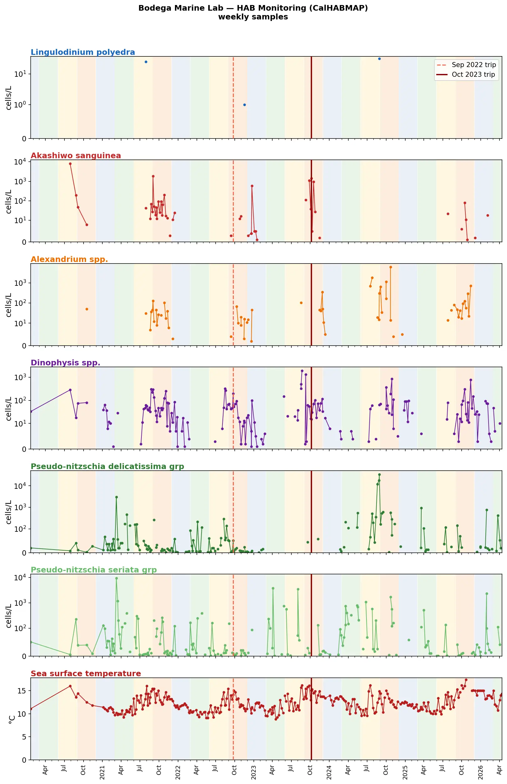
Raw data and plotting code: github.com/r-barnes/tomales-biolum.
Is it dark enough? Bioluminescence Night Planner
The night planner at the bottom of this page shows every night when the moon has set by 9 PM (so you'll be awake and have time to explore), or lunar illumination is <5%. The dark window runs from 1 hour after civil twilight until moonrise or civil dawn, whichever comes first. Times shown are shown in Pacific time. The values are calculated for Marshall Beach (38.163°N, 122.916°W), but that's a reasonable proxy for all of Tomales Bay. This ignores topography, so the sun and the moon will actually rise a bit later and set a bit earlier.
Check Show tides to overlay the day's high and low water times and heights. Tides matter for two reasons: most west-shore beaches disappear above 5 ft (bold entries), so you need enough beach above the waterline to camp; and tidal currents can make the Bay crossing harder away from slack water near a high or low. Tide predictions use harmonic constituents for San Francisco (NOAA 9414290) adjusted with the time and height offsets for Blake Landing (NOAA 9415396), the nearest NOAA subordinate station to the Marshall Beach. Predictions were spot-checked against NOAA's published tide tables for dates across 2026–2029 and agree within ±10 minutes and ±0.15 ft.